|
| The
strange Hole n' the Rock |

|
A far-western
movie landscape, the Valley of Gods |

| |
The very
tough road which passes through the Valley of Gods |

|
|
Some of
the Valley of Gods's rocks, they look like little mittens |

| 
|
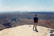
Me at Muley
Point, no photo can describe this place |


|
The I-163
approaching the Monument Valley |

|
We are
at the Monument Valley! |


|
The sunset
at the Monument Valley makes the sand looking like it's burning
|
|
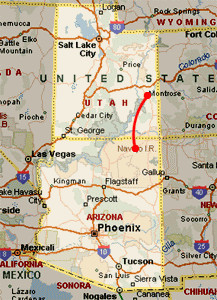
| Departure:
Moab, UT |
| Arrival:
Kayenta, AZ |
| Lodge:
Hampton Inn |
| Price:
99$+tax |
| Leg
Km : 338 (210 Miles) |
| Total
Km : 2964 (1840 Miles) |
Summary |
| |
-Valley
of Gods |
| |
-Muley
Point |
| |
-Goosenecks
SP |
| |
-Monument
Valley |
|
|

|
-click
on the lens to zoom- |
|
|

Tuesday, 29th July
(Moab)
We leave our Motel 6 when the morning has already begun. We plan
to arrive to the Monument Valley late in the afternoon to tour
the valley and enjoy the sunset. On the way we'd like to visit
Goosenecks SP. Saying the truth this area is full of things to
see and we have full will to see them all if we have enough time.
After few miles after Moab we stop to browse a strange shop called
Hole n' Rock. Just in America exist things like
that! The nice news is that this shop, something between kitsch
and flashy, is pretty famous!
Left the shop, we go on driving along the wonderful I-163
which will lead us to the Monument Valley. This highway offers
old far-west landscapes and it isn't difficult to feel part of
that America we have dreamed about and seen in movies.
Valley of Gods
After about an hour driving a sign indicates we're approaching
the Valley of Gods. As we did for Muley Point, we decided not
to "officially" include the Valley of Gods in our itinerary.
We did it because we weren't able to understand if they were or
not visitable without a 4WD. As soon as we leave the I-163 we
finish on a unpaved road which doesn't appear so terrible. An
information signboard at the entrance says nothing about the kind
of car that can access the area. So, we decide to go on. The only
other car we meet is a Ranger car. They just greet us and move
on by. We both think that if this road had been really so dangerous,
the Rangers would have surely stopped us. Encouraged by this thought,
we continue. We seem to be in a western movie set: the classic
scene where Indians run after a cowboy's stage coach. The road
gets worse and worse but, driving slowly, we have no problems.
But after a few hundred meters, the road gets very bad and we
stop, thinking about turning around. The road looks turning right
and this makes us hopeful we're near the end. Unfortunately is
not like this and we continue driving at 10-15 mph across holes
and rocks. We start getting pretty nervous since we've no idea
how far we are from the end and we can't even turn around because
we've already passed a few places that would be too risky to try
again in the opposite direction. A couple of times we climb up
on the top of some little hill. Magda stays down in the car to
check what should be coming and tells me how to proceed.
With lots of patience and curse words we finally reach the exit.
We needed about 1.5 hours to drive 17 miles. Was it worth it?
I would say yes, but my answer could have been very different
if our car had gotten stuck somewhere in the middle of the Valley
of Gods.
Muley Point
Even though the last hours haven't been the easiest of our trip,
we're too near Muley Point to miss this chance. We have to follow
a steep crook road called Moki Dugway
where some little stones cover a paved base. We must stop to get
directions and at the end we find the right turn. This road too
isn't not paved but compared to the Valley of Gods, we feel like
driving on a F1 circuit. Without problems we get to Muley Point
and no one is there but us. The view from Muley Point can't be
to described. You have a 180 degrees view and the only limit is
the blue sky at the horizon. Goosenecks SP is below us, the Monument
Valley can be seen far away and some other landscapes that remind
you of the typical canyonlands ones are righ above the overlook.
A-m-a-z-i-n-g!
The sun is right overhead and it's pretty hot. We'd like to stay
longer just in contemplation but there's lots to do. We drive
back on the Moki Dugway stopping frequently to enjoy beautiful
views. We can also see the Valley of Gods that, from here, it
sure looks safer than what we experienced just a few hours ago.
Goosenecks SP
Before we reach the I-163 we turn again. In half an hour we arrive
to the Goosenecks SP. There is no fee but there is no infrastructure.
We have a peaceful view almost completely to ourselves. Like Death
Horse SP, the river here seems to describe the forms of goosenecks
but there are many such formations here. The rocks are more massive
and darker. They almost look like turtles' shells. After reading
the little available information and snapping some photos, we
return to our car. It's 3 p.m. and we're pretty hungry and tired
after the stress of Valley of Gods. Once on the I-163, it doesn't
take long to get to Mexican Hat. Except
for the rock which gives its name to the city, there's not much
more. We fill up with gas and eat in the only available restaurant.
It's called Nave's and owners are Navajo.
The man prepares hamburger and the his wife watches the children.
The place is small and food is nothing special but we're hungry
and this is the only restaurant before Kayenta.
Monument Valley
The I-163, approaching the Monument
valley is unique. While we drive on the famous, often photographed,
straight part of this highway, we approach the famous buttes our
left while the red sand looks fusing the blue sky.
After leaving the I-163, we stop and browse in some of the little
Navajo shops. The items are nice and Navajo's are cordial.
We get to the real entrance of the Monument Valley when it's almost
5 p.m.
Tickets costs 5$ per person per day. First, we go to the visitor
center and get most of the information we need. We're specially
interested in the Tour to the Hidden Valley, usually lead by a
Navajo guide. All the tours we're offered are pretty short and
seem to be the same tours we can do by ourselves. We're not convinced
since we had read about something pretty different. If we have
to pay for a tour, we'd prefer something extensive but the ones
they offer don't seem right. We decide to think about it, and
in any case we could always join next morning's tour.
So, we get back in the car and we start exploring. The map we
got at the entrance briefly describes the eleven view points we'll
meet. We follow the itinerary and there's no chance of getting
lost since there's just one way to go. Monument Valley doesn't
really convince us. The views and landscapes are amazing but we
feel we're touring it more than exploring it. Navajo privacy must
surely be respected, but we feel as if we were on a roller coaster.
However, we like the place just the same. We wait for the sunset,
when the late sunlight makes the sand look like it's burning.
Spectacular!
After that we leave the Monument Valley and then head to Kayenta.
This town is tiny but looks a metropolis compared to what we've
seen south of Monticello. There is even a cow crossing the street!
We leave our luggage at the Hampton Inn,
one of the three Kayenta's hotels. Our room is nice and breakfast
is included.
After a shower to clean off the red Navaho sand, we go out for
dinner. There isn't a big choice so we choose the usual Burger
King. Same old food, but we can read the interesting
gratitude certificates hung to the wall, where President of the
United States thanks Navajo for their precious contribution to
the war. There're also brochures that tell the story that has
inspired the movie Windtalkers (where the Navajo language has
been used like a code to send encrypted messages).
Before sleeping we have to plan tomorrow's activities. The big
question: are we joining or not the Navajo morning tour? The tours
really haven't convinced us so we decide to pass them up. Gaining
time, we could change a bit our schedule and shorten the long
last two legs of our trip, from the Grand Canyon to LA and then
to San Francisco. Tomorrow we'll study a plan.
Previous |
Home |
Next |
|
|
|
Arches |
|
Lake Powell |
|